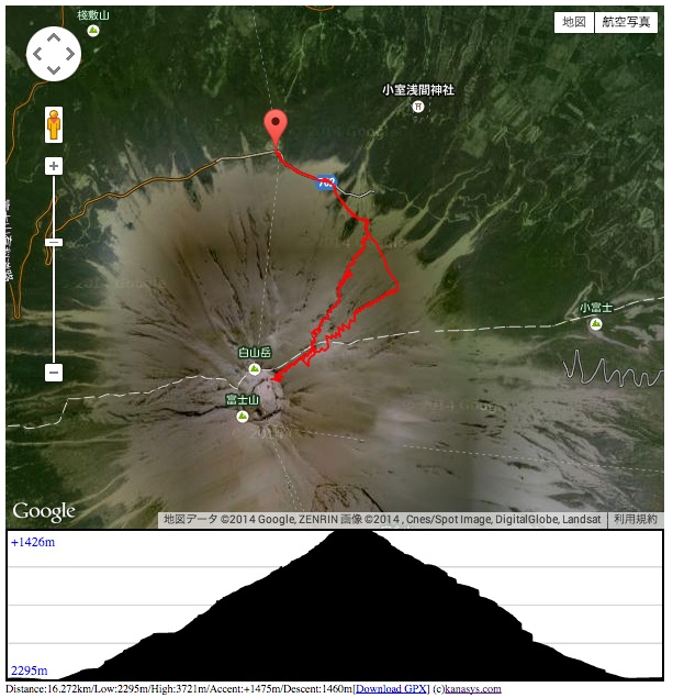
Plotting GPX track file with altitude graph
jQuery Plugin
jQuery plugin to show gpx track and altitude graph
Usage
Load from URL(function param)
<html>
    <head>
        <script type="text/javascript" src="http://ajax.googleapis.com/ajax/libs/jquery/1.5.0/jquery.min.js"></script>
        <script type="text/javascript" src="http://maps.googleapis.com/maps/api/js?libraries=geometry&language=en&sensor=false"></script>

        <script src='jquery.showgpxtracks.js' ></script>

        <script>
            $(document).ready(function(){
                $('#track').showGpxTracks('hiking.gpx');
            });
        </script>
    </head>

    <body>
        <div id='track' style='width:600px;height;400px;'></div>
    </body>
</html>
Load from GPX Text
<html>
    <head>
        <script type="text/javascript" src="http://ajax.googleapis.com/ajax/libs/jquery/1.5.0/jquery.min.js"></script>
        <script type="text/javascript" src="http://maps.googleapis.com/maps/api/js?libraries=geometry&language=en&sensor=false"></script>

        <script src='jquery.showgpxtracks.js' ></script>

        <script>
            $(document).ready(function(){
                var gpx='<?xml version="1.0" encoding="UTF-8"?><gpx version="1.1" xmlns="http://www.topografix.com/GPX/1/1"><trk><trkseg><trkpt lat="35.365968055555555" lon="138.73368555555555"><ele>3680.0</ele></trkpt><trkpt lat="35.36499416666667" lon="138.73331305555556"><ele>3712.0</ele></trkpt><trkpt lat="35.36499416666667" lon="138.73331305555556"><ele>3712.0</ele></trkpt><trkpt lat="35.36493166666666" lon="138.73317333333333"><ele>3712.0</ele></trkpt></trkseg></trk></gpx>';
                $('#track').showGpxTracksString(gpx);
            });
        </script>
    </head>

    <body>
        <div id='track' style='width:600px;height;400px;'></div>
    </body>
</html>
History
- 0.2.0: Added showGpxTracksString() and optionalUrl param of showGpxTracks()
Popular Articles from This Page


Top Page
Economizing Technology > Plotting GPX track file with altitude graph